


College Atlas & Trip Planner app for iPhone and iPad
Developer: E-Step Consulting, Inc.
First release : 16 Jan 2015
App size: 57.29 Mb
Mobile University College Atlas & Trip Planner is the latest addition to the Mobile University suite of college research applications. With College Atlas & Trip Planner you will be able to view a geographical representation of more than 4,500 colleges and universities in the United States.
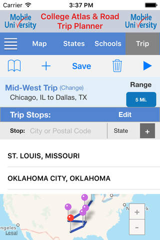
The trip planning features will allow you to plan a college road trip, and clearly identify which schools to visit. Simply specify your start and end points, and any stops in between, and your desired search radius, and the application will map your trip for you. The results will be a presentation of all the schools within the specified radius of each stop on your trip.
Schools can be searched by your current position, state or name. Summary and detail information in five (5) categories can be viewed for each school. Each search performed not only displays the search results on the map, but also provides the schools found in a sorted list, with address and phone number information for each school in the list.
If you use Mobile University College Search Pro, you can import your profile data to identify the schools offer you major, and that you match on for test scores and GPA. You can also, view additional detail information about a school directly in Mobile University College Search Pro simply by pressing the College Search Pro icon.
Some of the main features of the application are
- Geographically view schools by each of the 50 states and Puerto Rico.
- Search for a school by entering all or part of the name, and see all the schools across the country that contain the search text.
- Use your Mobile University College Search Pro profile to identify matching schools.
- Plan a trip with as many stops desired, and see all schools within a specified radius.
- Save your trips for later reference and easier recall.
- Four year and two schools are displayed separately to reduce clutter.
- Zoom to street level on any map view.
- Each school is represented by a color coded pin to indicate size and public/private classification.
- Clearly identify any school by selecting the school pin.
- View summary and detail information for any school displayed.
- See a sorted list of all the schools currently displayed on the map.
- Keep running notes on all the schools researched and visited
- Built in application help is provided to answer any questions about how to us a feature.
NOTE: The trip planning feature is not intended to provide navigational, or turn-by-turn, directions. Its main purpose is to provide a geographical representation of schools near a point, or stop, specified by geo-positioning.